
True Tales: On the street where you live
By George T. Comeau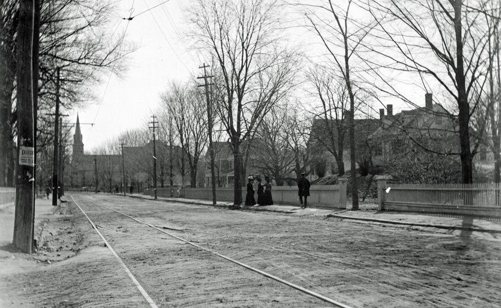
A view of Washington Street at Sherman Street taken in 1887. Note the trolley tracks and the distant view of the St. John’s Steeple. (Courtesy of the Canton Historical Society)
Canton has certainly come a long way since it was once part of Dorchester in the mid 1500s. And for folks who complain about traffic, here they join in a recurring theme throughout the history of the town. With over 440 public and private ways and perhaps a cumulative length of 115 miles of roadways, the history of our town can be read in street signs.
Some street names are easy — Dedham, Randolph, and Walpole streets — quite simply following along the road leading to where you want to go. If you are wondering where Sharon Street is, it existed in 1830 and now is called High Street.
Other street names are fanciful — Wisteria Way, Strawberry Lane, and Homestead Drive. And while there are plenty of Indian place names connecting to the people whose land we once wrested control from, the developers of one subdivision decided that a more grandiose approach would be to name their streets after the Sioux, Navaho, Seneca, Seminole, Mohawk, and Cherokee tribes. The naming of the Algonquin Estates neighborhood was done despite the fact that these historic tribes have nothing whatsoever to do with Canton.
I am a firm believer that street names should be tied to the historical events, people and places that are part of our historical record. When I was on the Planning Board, I named Thoreau, Aldrich, and Waterman roads — all named for writers or artists who had ties to Canton. And on the road where I grew up, just off Walpole Street, the small paper street was renamed Postfield Lane. The street is named in honor of my great-grandfather, who raised beagles at his AKC award-winning Postfield Kennels.
Of course, since developers actually build the streets on behalf of the town, for some years they decided to “commemorate” their own interests. Streets like Staiti Circle, Anthony Way, and Reynolds Street are pretty much self-named streets. There are great, big industrial streets that follow this same pattern: Shawmut, Dan and John roads all have no connection to our town other than the randomness of the developer’s whim.
The vanity of street names was not always in vogue. Street names had special meaning and a certain convenience to the traveler. The present-day Chapman Street was originally known as “Ye way to Old Forge.” It was simple: If you wanted to go to where the Old Forge was, you went along the way to Old Forge. At some point the Old Forge was forgotten, and instead a tribute to Oliver S. Chapman was in order.
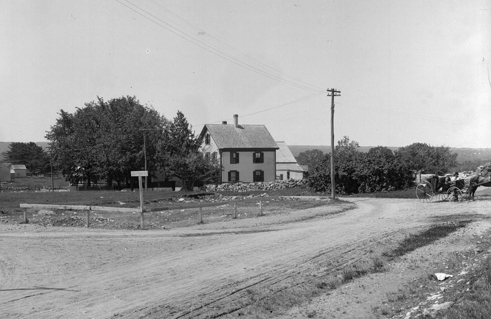
A view of Jackson and Chapman streets from the late 1800s. This photo was taken at the Spaulding Street Railroad Bridge looking west toward Norwood. (Courtesy of the Canton Historical Society)
Oliver Chapman was a wealthy railroad contractor who lived in Canton. When his first wife died, he married Elizabeth Otis, the widow of his close friend William Otis (who invented the steam shovel, then called a crane excavator) and renewed the patents on his best friend’s invention. Amassing a fortune, Chapman dedicated large sums of money toward improving Canton. Overseeing the construction of schools and public projects, his crowning work is seen in the adornment of the landscape of Canton Corner Cemetery, where he directed the public money toward expansion.
There are several streets in Canton named for industrialists: Kinsley for the founder of the iron works, Wattles for the manufacturer of elastics and suspenders, Messinger for the silk mill industrialist, and Dunbar for the colonial pianoforte and paper box maker.
Other better-known commemorative streets in Canton include Revere, Gridley, Sherman, and Royall Streets — the latter named for Isaac Royall. As for historic associations, it turns out that Royall, a British Loyalist, was an Antiguan slave trader and held slaves on his farm at the foot of Blue Hill in what was then Stoughton.
A few of our streets commemorate U.S. presidents: Jackson and Van Buren, along with Washington Street. Once known as The King’s Highway, Washington Street is perhaps the oldest road in Canton, likely starting as a Native footpath through the wilds of Dorchester. Our “Main Street” began colonial life as a small cart path and has been known by so many names over the years: the Road to Billings, the Country Road, the Road to Rhode Island, the Taunton Old Road, the Main Road, the Great Road, and perhaps several other names now lost to history.
While likely in use since the middle of the 17th century, it was formally laid out in 1700 by the selectmen of Dorchester. A more precise layout was completed in 1713. The surveyor’s work created a road fixed at “three rods wide.” The rod as a form of measurement had been defined by England in the Composition of Yards and Perches dating to the late 13th or early 14th centuries. Of course, as the English expanded their use of the new world, they brought with them the forms of measurements and definitions for laying out land and properties.
Three rods may not sound like much, but in fact our modern-day Washington Street varies little in width compared to the original layout of over 300 years ago. At 16.5 feet per road, Washington Street is 49.5 feet wide along its course, and while it varies in some places, the original layout has not changed all that much since the original plans were drawn. In fact, in 1928 the county laid out Washington Street, and it now measures between 50 and 60 feet along the entire length.
Ancient roads still exist throughout the town; some are abandoned and others are a hot topic of debate, calling for straightening or widening where safety permits. Take York Street as it connects to East Stoughton, originally named Pigwackett. Very early on in our history this section of town was called York in commemoration of York, Maine.
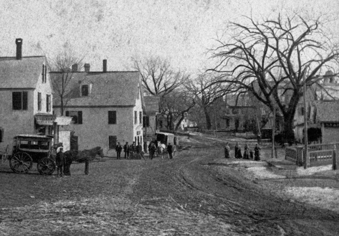
One of the earliest photographs of Canton Center, taken around 1870 or later looking south toward Mechanic Street (Courtesy of the Canton Historical Society)
In 1692, during a bloody massacre, 200 to 300 Abenaki Indians slaughtered 100 English settlers as part of King William’s War. In honor of the survivors who relocated to Canton, York Street commemorates their original home. A report on the naming of streets in 1881 observed: “Let us still hold onto it, for it connects us with an event in history, touching and terrible in its details, in which some of our ancestors were participants.”
So many of our street names are lessons in history. Bolivar Street was opened as a roadway in 1792. At the site of the present-day DPW garage stood a factory called the Bolivar Works, named for Simon Bolivar, the liberator of South America from Spain. Bolivar Street is a reminder of the greatness of this man, who has been hailed as the “George Washington of South America.” Nathanial Way was named for Nathanial Fuller, who lived in the general vicinity in the mid 1700s.
Then there are the streets that are ghosts — streets that no longer exist but can be seen if you know where to look. Some of these roads travel on private property and have been hidden for 250 years or more. Back Street, which parallels Elm, is a perfect example. Now hidden from view, an early stone bridge vaguely guides the visitor along the outline of the road. Also, an ancient road in the woods through the Audubon land was likely the road that David Tilden complained about when seeking relief from traffic in the early 1700s. If you look closely on your right, just before St. Mary’s Cemetery along Washington Street, you will see a private path long forgotten that leads across the land of the Massachusetts Hospital School.
Pleasant Street, another ancient way, is today part of the systems of weights and measures that help us ensure that taxicabs in Canton have accurate meters. Each year, the commonwealth’s sealer of weights and measures depends upon the marks on the road, made every fifth of a mile along the entire length to Stoughton. Assistant Town Engineer Lisa Grega knows where the survey nails are, and each August the cab meters are tested along the two-mile stretch of roadway.
There are names that mean absolutely nothing, and historically they have stuck. Green Street is an example. A report from the late 1800s states, “It is the name of a color, not given in honor of any distinguished townsman named Green. The street is no more green than any other country road.” The same can be said of all the “tree roads.” One fellow local historian (who shall go unnamed) recently opined that the subdivisions named after trees are most notable for the fact that the developers cut all the trees down to build the houses. Elmwood, Cedarcrest, Ashcroft, Pine Cone, Birchcroft … hmmm, he may well be on to something.
There are plenty of historical associations left for new streets, and the Planning Board works closely with the Historical Commission to ensure that new streets have appropriate connections to our past. Who knows, 50 years from now we may well be pleased to be sitting in traffic on Connolly Boulevard, Elkort Road, Salvatori Street, perhaps even Del Vecchio Drive. After all, there already is a Burr Lane.
Short URL: https://www.thecantoncitizen.com/?p=14910