
True Tales from Canton’s Past: The View Beyond
By George T. Comeau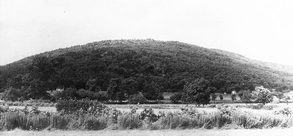
The Blue Hill with fields and farms at her feet, long before the highway cut through the town, circa 1900 (Postcard in the collection of the author)
The boys set out on an August day to swim at Houghton’s Pond. It was a bucolic summer day; a light breeze pushed big puffy clouds through the sky. Tossing their hats, jostling each other and generally roughhousing, they tumbled through the fields like lion cubs out on the savannah.
For most youngsters, summertime in Canton in the 1880s was a place full of wonders. A boy could swim, fish, play ball with his friends, spend from dawn to dusk outside, and hardly have a care in the world. Sure, some would work in the factories or on the family farm, but for most it was a time of whiling away the hours in the great outdoors.
John and Charles Davenport were born in Ponkapoag, grew up there, and spent nearly all their youth in the shadow of Blue Hill. Their family had come to Canton; well, before it was Canton or even Stoughton. The first Davenport, also named John, appears in our history as a lessee on Indian land in 1705. There is no evidence he actually lived here, but his son John was born in Milton in 1695 and purchased his estate from Jonathan Puffer in 1717. The house is still standing, although grossly bastardized over time. Hidden in the weeds and woodland just before the Ponkapoag exit off of Route 138 onto Interstate 93, look to the right and there is Davenport Lane, at the end of which is likely the oldest surviving house in Canton.
The Davenport House had been in the family for more than 200 years. And it is a sprawling place full of quirks and additions over time. Tradition asserts that the Indians helped build the house. Dating to as early as 1711, it was built for Puffer, who is referenced in historical documents as being “allowed the liberty to get one load of clapboards and two loads of cedar bolts from the common swamps.” Whether the young boys in our story lived in this exact house or a house nearby, it makes no matter, for at one point or another the Davenports have been in our town for well over two centuries.
The boys ambled down the dusty road, and with only about a half mile to go before they reached the pond, they suddenly switched direction. Today would be a perfect day to climb Blue Hill. It is not as if they had never been there before. Hardly a child in Canton had not been on a picnic or outing at some point in their youth where they had climbed to the top of the hill. And while today there are several routes to the top, these are more modern trails, which in some cases were built over existing routes.
There are plenty of paths to the top of Blue Hill, but the most direct and likely closest to the ones used by our earliest settlers and passed down through history is on the southerly side leading up from Blue Hill River Road. The fields and farms that once dotted this pastoral area are long gone. The range has been transformed by human hand, the meadows replaced by either the super-highway or multinational corporations. If you want to take the path that our young boys took, the trail is most easily accessed starting from the parking area one-eighth of a mile west from Blue Hill River Road. Follow an unnamed side path that parallels Hillside Street on the north side, west for 275 feet to the Wildcat Notch Path trailhead. There is a granite monument marking the path.

Wildcat Notch on a trail leading towards the summit of Great Blue Hill (Photo by the author)
The boys ascended easily, through the soft pine where the needles had fallen to create a scented woodland carpet. As they rose, their faces flushed, but their young legs brought them higher into the hill. As the name suggests, there is a “notch” along the path, which leads to Coon Hollow. And if you hike this route, it becomes apparent that these historic names are beautiful throwbacks to another time and place. Soon, the steepest part of the climb emerges, and just as the boys did, you will scramble a bit to ascend to the top.
This is the top of Blue Hill; note the fact that this writer hardly uses the plural. A Canton poet, writing in 1911, described it as having “infinite variance of changing moods.” And as you ponder the name, the hill changes color whimsically throughout the day. “At dawn of a clear morning it looms blue-black against the rosy deep of the sky. At noon it looms still but friendly and green, so near that the eye may pick out the shape of each tree that feathers the jutting crags. At noon of such a day Ponkapoag Hill with its houses bowered in green seems a part of it the half mile of intervening space making no impression on the eye. As the sun sinks a haze rises from the rich farming land, which lies level … The spirit on slender ropes of mist is at work, and through this vapory amethyst the larger hill withdraws into soft colors of blue that grow violet purple with the coming of dusk below and the rosy afterglow of reflected sunset in the sky above.”
This is the place that Captain John Smith named the “Cheviot Hills.” Yet as far as the earliest maps it has been called the Blew Hill. The top of the hill is an amazing place to spend time, and humans have done so for thousands of years. Pre-historic man crossed the same trails that we walk today, more than 10,000 years ago. In 1798 the owners of the Billings Tavern in Milton decided to build a scenic observatory on nearby Great Blue Hill for the enjoyment of their guests. It was a three-story wood structure with plank seats and railings on the outside, and neighbors built stairs on the inside while tavern patrons contributed to its cost.
During the Revolutionary War, the top of Great Blue Hill was used by the military as a lookout point to detect approaching enemy forces by land or sea. Barrels of tar were set afire to create beacons that could be seen from Boston. During the war of 1812, Great Blue Hill afforded views of the battle between the USS Chesapeake and HMS Shannon.
By the time the boys had made their summit, there stood a brand-new building — a fortress-like castle. On the ruins of the historic lookout rose the Blue Hill weather observatory. And on that summer day, the Davenport boys got the unique chance to climb the tower and witness the spectacle that is New England. Over the intervening 125 years much has changed. For one thing, there are more trees today, and of course ribbons of highway and steel and glass rising to reach the sky. But in 1885, to the eyes and minds of a 13 and a 10-year-old boy, the site must have been inspiring.
Almost due north Charlie could pick out Memorial Hall at Harvard in Cambridge, 11 miles distant. Three more miles beyond stood the Unitarian Church in Medford. To the right they saw Holt’s Hill in Andover and Bald Pate in Georgetown. John pointed out the golden dome of the Massachusetts State House glimmering in the afternoon sun, and just to the right and 27 miles beyond he spied the State Insane Asylum in Danvers. The boys marveled at all the sails in Boston Harbor, and even a few steamships dotted the horizon. Islands, forts, lighthouses — all conjured up stories of past wars and fantastic voyages. The view that day was clear to Marblehead and the Eastern Point Lighthouse in Gloucester.
To the east the view looked down Massachusetts Bay and several hundred miles are still visible today. The horizon crosses the view at precisely 33 3/8 miles. Sails could still be seen beyond that point, yet the hulls remained hidden by the curve of the earth. Nantasket comes into view, “appearing like a bead strung on a thread.” Minot’s Light was seen that day, as was the large brick building at Thayer Academy in South Braintree.
From their perch the boys saw Ponkapoag Pond and the silver turnpike and trolley line as well as children swimming at Wissahissick (Houghton’s) Pond. The Canton Reservoir glimmered and the factories all belched soot grey smoke from their stacks. Manomet Hill in Plymouth side by side to Holbrook just beneath. Duxbury, Randolph, and Brockton all came into view. The boys discovered the water works in Fall River 35 miles away.
Even today, on the clearest of days the view from Blue Hill extends to Wachusett Mountain and further on to Grand Monadnock Mountain in Jaffrey, New Hampshire, some 67 miles away. Yet perhaps the greatest joy of those boys on an August day was seeing their home from another angle and gathering the sense that there was a world beyond Canton. The view from Blue Hill provided generations of men, women, and children the opportunity to see their place in a new relationship to the whole. It is an experience worth having and worth repeating, and can happen only in Canton.
Short URL: https://www.thecantoncitizen.com/?p=30358