
True Tales from Canton’s Past: A Lithic Journey
By George T. Comeau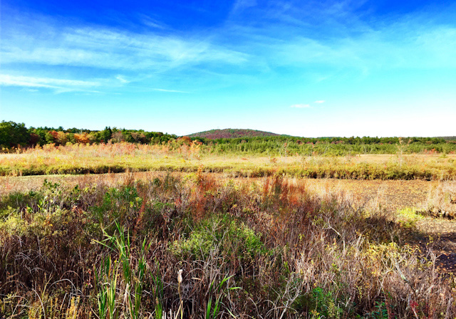
This unchanged view across Ponkapoag Pond is quite close to a native site used for perhaps 5,000 years as an autumn hunting camp. (Photo by the author)
As Joe Bagley speaks, his passion for archeology flows. Standing in front of an overflowing room, Bagley looks the part of an archeologist — rugged boots, tough pants, and a boyish smile. The audience hangs on his every word. This is the Friends of the Blue Hills’ 35th anniversary meeting, and the city of Boston archeologist reveals the amazing history that is beneath our feet. In a word, his talk is about stewardship.
The Blue Hills Reservation is such an amazing place. As someone who has hiked hundreds of miles within its borders, I never cease to marvel at this historical place in our own backyards. And this is the perfect time of year to get out and walk on the same trails that man walked on more than 8,000 years ago.
The Blue Hills were so named by early European explorers who, while sailing along the coastline, noticed the bluish hue on the slopes when viewed from a distance. The blue comes from the rocks that formed the geology of the hills 600 million years ago. It may be hard to believe, but this site was formed as a result of a large volcano that has been worn down over these millions of years to be the site we know today. And the blue hue of the rock tells a story that extends back almost 10,000 years ago when Native Americans created a bustling community on this land.
In his mind’s eye, Bagley, like many of the archeologists who have come before him, can see the camps, the workshops, the quarry sites, and the hunting grounds of a great people who were the first stewards of the land along the Neponset Valley. “Many of the trails we walk today are the exact same trails that have been used for thousands of years,” explained Bagley.
Today the trails are used for recreation, but thousands of years ago these were the paths used to commute between quarries to workshops and then onto hunting grounds. The rocks that crunch underfoot tell the story of not only the geology of the Blue Hills, but also the archeology. It is in the rocks that we start to see why this was the center of industry for early man.
Bagley tells of one “aha” moment. “There was a site that I had read about just south of Granite Links Golf Course, and while still a student with some time on my hands, I took an afternoon treat and hiked to look for this area,” he said. “Based on what I had read, I was not prepared for the scale. I mean, you are looking for something and then you discover it is so large you are actually standing in it.”
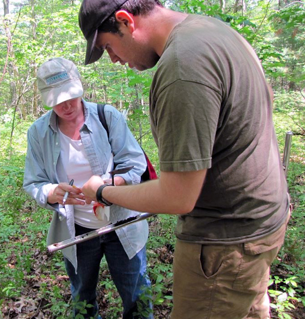
City of Boston archeologist Joseph Bagley conducting field research (Courtesy of Joseph Bagley)
Bagley said that the personal discovery was “mind blowing.” What he stumbled upon on the western side of the Blue Hill Reservation was the debris of a major prehistoric quarry.
Bagley was off the trail and climbing up the hill, expecting to see rocky outcrops, but instead there were terraces and the back was stone. “I was looking for the rock outcrop, and then I realized there were flakes everywhere,” he said. “The rock was being dug from the un-weathered rock, which would make for stronger tools. The natives were taking the cobble out of the ground to create the rough shapes, leaving behind mounds in the millions of waste products.”
At the top of the hill is an old weathered cellar hole of a farmhouse, and the foundation was made up of the byproducts of stone tool making. Essentially, the colonial farmer was unknowingly recycling — using waste from thousands of years ago.
What Bagley and other archeologists know is that the Blue Hills Reservation is a treasure worth studying and protecting to understand the tools used by earliest man. While the geology of the Blue Hills was studied as early as 1900, it took almost four decades later for archeologists to delve into the area. In the late 1930s Harvard’s Peabody Museum began to turn its attention toward the Blue Hills. Radiocarbon dating was just getting into the science, and the archeology team knew that many of the lithic — or stone tool — artifacts were made from stone only found in the Blue Hill range. The Lithic stage was the earliest period of human occupation in the Americas, occurring during the Late Pleistocene period, to a time before 8,000 B.C. The process of flint knapping yields lots of debris. The term knapped is synonymous with “chipped” or “struck.” Throughout the Blue Hills you can find evidence of flaking, pecking, pounding, grinding, drilling, and incising rock in such a way that this area becomes a significant historical resource.
Canton is a hotbed of early archeological artifacts, and in the collection of the local historical society there are artifacts such as mortars, also known as metates, as well as pestles, grinding slabs, hammerstones, spear points, and scrapers. For many people who claim to hunt for arrowheads, they are more likely to find spear points and knives, since the bow and arrow was only developed about 1,000 years ago. The tools that have been found are much older.
And we have had local archeologists who have revealed our unique past. Allan Lowry, a much-beloved Canton resident, found much of what has been discovered beneath some of the most important sites in our town. Lowry passed away a number of years ago, but his wife, Elaine, recalls how he started. “As a young couple we were raking leaves in the yard, and I found a stone that looked like a hammer,” she said. “I guess from that point on he was hooked. Each Sunday I would drop him off at a dig site, and then I would go to church — he wasn’t a church goer.” For Allan Lowry, his religion was found deep in the ground and extended back over thousands of years.
Lowry was responsible, in part, for excavating the Green Hill Site, now a protected location and part of the National Register of Historic Places. Highway construction once threatened this place, but today it is now part of the Blue Hills Reservation. The middle and late archaic site is located on the Milton/Canton line and encompasses part of the Metropolitan District Commission’s purchase of 78.44 acres of Augustus Hemenway’s estate in 1940.
In 1883 Hemenway purchased several acres of the site from a family of horse fanciers whose stables then graced the neighborhood. By about 1900 Hemenway had purchased the remainder of the site, and upon it situated this “South Farm.” A site report from 1980 writes, “The gentle slopes around the site’s kame hill, which had been used for occasional tillage prior to 1883, reverted back to grazing land. The Hemenway cow pasture was situated just east of the hill. On the site, partridge and quail were hunted. On the hill itself, virtually treeless until about 40 years ago, strawberries could be picked in season amid scraggly undergrowth, which discouraged all but the most intrepid. Quite possibly the hill has been little disturbed by human activity since prehistoric times. In any case the present mixed pine hardwood cover resembles the hill’s prehistoric appearance.”
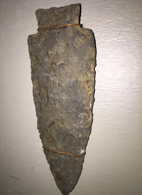
A large Normanskill-type stone spear or knife point from the Late Archaic period (Canton Historical Society)
In the spring of 1966, more than 200 stone tools were found prior to local highway construction. The site was excavated in two periods, 1966-1972 and then again from 1972-1976. The conclusion made through the amateur archeology was that this was a site likely used as an autumn campsite, offering easy access to the felsite quarries of the Blue Hills and providing a manufacturing site for tools.
Bagley knows the importance of the Blue Hills Reservation, and his voice wavers with emotion as he describes the place as a “mecca of stone production.” Wampatuck Hill in particular, just north of the reservoir, is 353 feet of rhyolite and largely a source for the raw materials of tool making. Yet another site near Ponkapoag Pond near the golf course yielded evidence of almost 5,000 years of use by people of the early and middle late archaic periods. Taken in its totality, the Blue Hills Reservation in one fashion or another represents a human timespan starting at the Paleo-Indian Period and continuing through the Archaic, Early and Middle Woodland Periods, and of course the Contact and Colonial Periods. We are talking 16,000 years of man’s use of the natural resources along the Neponset River.
Can we still learn from the Blue Hills? The answer according to Bagley is a definitive “yes.” During the Middle Woodland Period (1000 – 3000 years ago) – trade routes exploded and goods moved from and between places as far away as Pennsylvania and Coxsackie, New York. We know this, because we have found tools made of stone that only came from these places. And then at 1000 years ago all trade stopped. The tools that are found from this period only come from Lynn or Saugus or the Blue Hills. For Bagley, there will always be questions, and fortunately we have the Blue Hill Reservation protecting the answers. As Bagley puts it, “this place is right, this place is good, our human instincts relate to these sites.” For more than 35 years the Friends of the Blue Hills have protected the paths and trails that have been travelled by ancient man. Next time you hike, take a look down and travel back to an ancient time and place.
Short URL: https://www.thecantoncitizen.com/?p=27206